The fastest, most scalable method available for identifying natural gas leaks, meeting PHMSA and EPA compliance requirements, and protecting pipeline integrity — covering hundreds of miles in a single day.
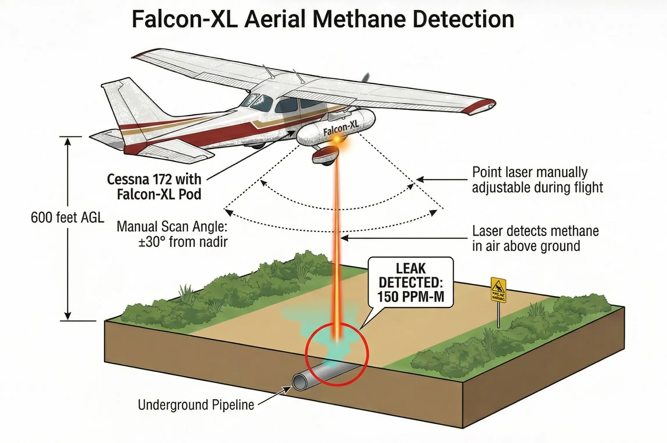
Aerial methane detection is the process of surveying natural gas pipelines from a manned aircraft equipped with laser-based sensing technology. As the aircraft follows the pipeline corridor, onboard sensors continuously scan the air column below for methane concentrations — pinpointing leaks in real time without the need for ground-based inspection crews.
Vanguard's aerial methane detection services and sensor technology are purpose-built for the pipeline industry — backed by FAA and EASA certifications and validated across more than 44,000 miles of pipeline in partnership with Energy Transfer.
Compared to walking or driving surveys, aerial methane detection covers dramatically more ground per day, reaches terrain that is inaccessible on foot, and delivers GPS-referenced leak data that integrates directly into GIS-based compliance and integrity management systems.
Whether you need a fully managed patrol service or a sensor system for your own aircraft, Vanguard gives you the tools to find leaks faster, document compliance confidently, and keep your operation running without interruption.
Vanguard's aerial methane detection is powered by TDLAS — Tunable Diode Laser Absorption Spectroscopy. This is the laser-based sensing technology recognized as the gold standard for aerial pipeline leak detection by PHMSA and the broader pipeline industry.
A Class 1 (eye-safe) infrared laser emits a beam tuned precisely to methane's molecular absorption wavelength, directed at the air column below the aircraft.
The beam passes through the air column and reflects off the ground surface, returning through the same column of air to the sensor.
When methane is present in the air column, it absorbs a measurable portion of the laser energy. The sensor records the methane concentration in parts-per-million-meter (ppm-m) in real time.
GPS coordinates are automatically paired with each reading, producing a continuous, georeferenced leak detection dataset along the entire pipeline corridor.
Post-flight data is delivered as KMZ (Google Earth compatible) and CSV files within 24 hours of mission completion — ready to plug directly into your existing GIS and integrity management workflows.
Drones have a role in point-source inspection and facility-level surveys. For the linear pipeline corridor patrol that PHMSA compliance requires — covering tens or hundreds of miles per mission — fixed-wing aerial detection is the operationally superior approach.
| Factor | Fixed-Wing (Vanguard Falcon-XL) | Drone (UAV) |
|---|---|---|
| Daily coverage | Hundreds of miles per day | Typically 10–30 miles per day |
| FAA certification | FAA/EASA STC-certified | Part 107 only; no STC pathway |
| BVLOS operation | Standard manned operation | Requires FAA waiver |
| PHMSA acceptance | Yes — established compliance pathway | Limited acceptance to date |
| Terrain flexibility | Remote, rural, and complex terrain | Limited range; battery constraints |
| Cost per mile at scale | Lower at transmission-line distances | Higher for long-corridor surveys |
Aerial methane detection requires no pipeline shutdowns, no ground crew coordination, and no changes to your existing patrol schedule. The Falcon-XL mounts to aircraft already in service, or Vanguard deploys its own patrol aircraft and crew.
The Vanguard iPad interface displays live methane concentration readings during the mission. When a leak indication is detected, the pilot and observer are alerted immediately — enabling same-day prioritization of repair resources.
Post-flight data is delivered as KMZ files (Google Earth compatible) and CSV files within 24 hours. Outputs plug directly into your existing GIS and integrity management workflows — no proprietary platform required.
The Falcon-XL has been validated across more than 44,000 miles of pipeline through Vanguard's partnership with Energy Transfer, one of North America's largest pipeline operators — field-verified detection at enterprise scale.
FAA and EASA certified. STC-approved for Cessna 172, 182, and 206 fixed-wing aircraft, Robinson R44 and R66, MD-500, and Bell-206 rotorcraft.
| Specification | Value |
|---|---|
| Gas Detected | Methane (CH₄) |
| Detection Threshold | 50 ppm-m at 600 ft AGL |
| Flow Rate Detection | Under 10 kg/hr |
| Probability of Detection | 90% at 10 kg/hr (staged-leak verified) |
| Optimum Detection Altitude | 600 ft AGL |
| Maximum Detection Altitude | 1,000 ft AGL |
| Maximum Airspeed | 130 knots |
| Laser Classification | Class 1 — eye-safe, non-harmful |
| Response Time | 0.2 seconds |
| Data Output | KMZ (Google Earth), CSV |
| System Control | iPad app and handheld remote |
| FAA/EASA Certification | Certified; STC-approved |
| Compatible Aircraft | Cessna 172, 182, 206 | R44, R66, MD-500, Bell-206 |
| Operating Conditions | Day or night; cloudy or sunny; no visible moisture* |
*Snow cover may reduce system sensitivity.
Vanguard offers two delivery models for aerial methane detection — designed to match different operational structures and compliance timelines.
Fully managed aerial methane detection. Vanguard supplies the aircraft, crew, and Falcon-XL sensor. You receive georeferenced results within 24 hours.
Lease the Falcon-XL for your own patrol aircraft and flight crews. Fly your routes on your schedule with Vanguard's sensor technology onboard.
Vanguard's aerial methane detection capability has been validated at scale through an operational partnership with Energy Transfer, one of North America's largest natural gas pipeline operators. The Falcon-XL system has been deployed across more than 44,000 miles of pipeline in active patrol operations — demonstrating consistent detection performance across diverse terrain, pipeline types, and operating conditions.
Talk to a Vanguard specialist to discuss your pipeline system, patrol requirements, and the fastest path to a compliant aerial methane detection program.